
Rio Grande Gorge: Flying Above One of New Mexico's Great Landscapes
A September Day With Paulette, the Outback, a Drone and the Rio Grande
By Pat McCarty
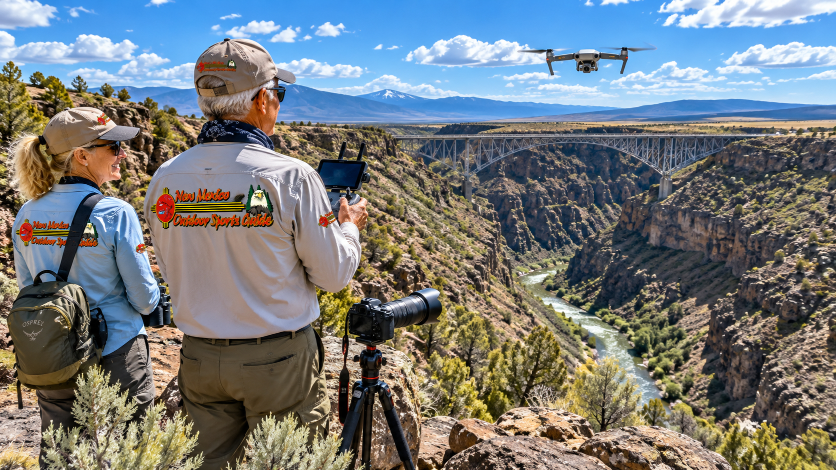
Yesterday morning Paulette and I loaded the camera gear and drone into the Outback and headed north toward Taos.
We've made that drive more times than I could begin to count.
Yet somehow the Rio Grande Gorge never becomes ordinary.
You can know it's coming. You can have photographed it before. You can have stood on its rim in summer heat, watched snow settle into it during winter, driven along the river below and looked up at canyon walls that seemed determined to scrape the blue out of the New Mexico sky.
And still, when that enormous crack in the Taos Plateau opens before you, you stop and look.
Yesterday we went specifically to look at it from another perspective.
From the air.
I've been a pilot most of my life. I earned my commercial license and flight instructor ratings and accumulated more than 2,600 hours in airplanes. For about ten years I flew a Beechcraft Baron around the country as a company pilot.
So I've always been fascinated by the view from above.
A drone gives me a little piece of that world again.
It isn't the same as pushing the throttles forward on a Baron, climbing through a few thousand feet and watching the landscape unfold beneath the wings. A drone stays much closer to Earth, and federal rules deliberately keep it there.
But when that little aircraft lifts from the ground and the camera begins climbing above the sagebrush, something remarkable happens.
The familiar becomes unfamiliar.
And yesterday, the Rio Grande Gorge became something entirely new again.
What Makes the Rio Grande Gorge So Extraordinary?
From ground level, northern New Mexico's Taos Plateau can fool you.
Drive across it and you see an enormous high-desert plain covered with sagebrush, rabbitbrush, piñon and juniper. The Sangre de Cristo Mountains rise dramatically to the east, while volcanic cones punctuate the broad plateau.
Then the earth simply opens.
The Rio Grande Gorge slices through that plateau in a tremendous dark trench.
Geologically, this isn't simply a case of a river patiently sawing its way downward through solid country. The gorge is associated with the Rio Grande Rift, an enormous zone where Earth's crust has been stretching and thinning for millions of years. Volcanic activity subsequently spread basalt across much of the Taos Plateau, and the Rio Grande established its course through this fractured landscape.
Today the result is one of the defining geographic features of northern New Mexico.
The Bureau of Land Management protects much of this country within Rio Grande del Norte National Monument, an extraordinary landscape encompassing the Rio Grande and Red River gorges, volcanic tablelands, mountains and wildlife habitat. (Bureau of Land Management)
I've explored parts of it on foot over the years, and that's a completely different way to understand the place. My story about hiking the Chiflo Trail at Wild Rivers Recreation Area follows one of those journeys down from the rim toward the Rio Grande.
From the trail, the gorge surrounds you.
From a drone, you begin to understand its shape.
Seeing the Rio Grande Gorge From a Drone
This was what Paulette and I had come to capture.
From the ground, your eyes tend to concentrate on individual pieces of the landscape.
A basalt cliff.
A bend in the river.
A distant mountain.
A bridge.
A patch of cottonwoods.
The drone camera changes that relationship.
As the aircraft rises, those individual pieces begin joining together.
Suddenly you can see the Rio Grande bending through the canyon floor while the plateau stretches outward on both sides.
The canyon walls stop looking like separate cliffs and become part of a long geological wound across the landscape.
Roads that seem substantial from behind the windshield of the Outback shrink into narrow lines.
Vehicles become specks.
And the Rio Grande becomes a ribbon of water far below.
For somebody who spent years looking down from an airplane, there is something wonderfully familiar about that transformation of scale.
But there is also a major difference.
From an airplane at altitude, you see the grand landscape.
With a drone, you can see the details within the grand landscape.
You can photograph the texture of basalt.
You can follow a line of cottonwoods.
You can watch sunlight and shadow move across the canyon walls.
You can reveal how a trail snakes toward the river.
That's what makes aerial photography such a powerful storytelling tool.
The Rio Grande River at the Bottom of It All
The star of the show isn't really the gorge.
It's the river.
Without the Rio Grande River, this landscape would tell an entirely different story.
The Rio Grande begins in Colorado's San Juan Mountains and travels south through the San Luis Valley before entering New Mexico.
By the time it reaches the Taos country, it has entered one of the most spectacular portions of its journey.
Far below the rim, the river passes through basalt canyon country that supports fishing, hiking, kayaking and some of New Mexico's best-known whitewater rafting.
I've written more broadly about the Rio Grande River in New Mexico, but nowhere does the river display its wild personality quite like it does in this northern canyon country.
At river level, the Rio Grande can feel intimate.
You hear water tumbling around boulders.
Cottonwoods rustle overhead.
A raven calls from somewhere on the cliffs.
The canyon walls block much of the world beyond them.
From the air, however, you see that intimate little river connected to an immense landscape.
Both perspectives are true.
That's one reason I keep carrying cameras.
The Rio Grande Gorge Bridge
And then there is the bridge.
Few man-made structures in New Mexico occupy a landscape quite as dramatically as the Rio Grande Gorge Bridge.
Completed in 1965, the steel bridge carries U.S. Highway 64 across the canyon northwest of Taos. NMDOT lists it at 1,272 feet long and approximately 650 feet above the Rio Grande. The department owns and maintains the bridge, while surrounding lands are managed by BLM and Taos Pueblo. (New Mexico Department of Transportation)
Six hundred and fifty feet.
Standing on the bridge, that's a number you can feel in the soles of your boots.
Look through the railing and the river seems impossibly far below.
Cars and trucks roll across the bridge as though crossing any ordinary piece of highway, but there is nothing ordinary about what lies beneath them.
From a drone perspective, the bridge becomes even more interesting.
Instead of seeing the bridge as the destination, the aerial perspective shows it as a thin human line spanning an enormous natural divide.
The gorge dominates.
The bridge merely crosses it.
I rather like that arrangement.
Human engineering is impressive.
Geology still gets the last word.
More Than a Bridge View
Visitors sometimes drive to the Gorge Bridge, walk out for photographs and assume they've seen the Rio Grande Gorge.
They've seen a magnificent piece of it.
But only a piece.
The gorge stretches through a much larger landscape, and some of my favorite country lies north around Wild Rivers and south toward Pilar.
At Wild Rivers, the Red River joins the Rio Grande deep beneath the plateau. Hiking there gives you an appreciation for just how much vertical country separates the rim from the water.
Our Bear Crossing Trail hike into the Rio Grande Gorge offers almost the opposite experience from yesterday's drone flight.
One takes you upward into the sky.
The other takes you downward into the canyon.
Both change your sense of scale.
The Rio Grande Gorge Is Alive
It's easy to become so fascinated by geology that we forget this enormous canyon is also habitat.
The Rio Grande corridor supports an impressive variety of wildlife.
Depending upon location and season, the broader monument country can hold elk, mule deer, pronghorn, black bear, cougar, coyotes, river otters, beavers and numerous smaller mammals.
Then there are the birds.
Golden eagles and other raptors use the cliffs and open country. Waterfowl follow the river corridor. Ravens seem particularly at home here, riding invisible currents above the canyon with the casual confidence of creatures that figured out flight long before we did.
That's another reason drone pilots need to behave responsibly.
We're visitors in their airspace too.
Drone Safety at the Rio Grande Gorge
My aviation background probably makes me more conservative about drone flying than some folks.
That's fine with me.
A drone may fit in a backpack, but once it leaves the ground it is an aircraft operating in the National Airspace System.
That deserves respect.
Current FAA rules require recreational pilots to maintain visual line of sight, give way to other aircraft, comply with applicable airspace restrictions, take and carry proof of the TRUST safety test, and generally remain at or below 400 feet above ground level in uncontrolled Class G airspace. Drones requiring registration must also comply with Remote ID requirements unless operating under an applicable exception such as within a FRIA. (Federal Aviation Administration)
And here's an important point for anyone creating photographs or video for a website.
The FAA says the distinction between recreational and non-recreational flying depends upon the purpose of the flight, not simply whether somebody was paid. Part 107 is the default framework for most non-recreational small-drone operations. (Federal Aviation Administration)
So before I fly, I want to know:
What airspace am I in?
Are there temporary flight restrictions?
Is the launch location legal?
Are there people nearby?
Are manned aircraft operating in the area?
Is the weather suitable?
Can I maintain visual contact with the aircraft?
And is the flight recreational or being conducted for another purpose?
The time to answer those questions is before the propellers start turning.
A Gorge Creates Special Flying Challenges
The Rio Grande Gorge adds another layer of difficulty.
Canyon terrain can create deceptive wind.
Air moving across the plateau can tumble over the rim and produce turbulence, updrafts and downdrafts.
The aircraft may look perfectly stable from where you're standing while experiencing something quite different a few hundred feet away.
Then there is the temptation created by the gorge itself.
You want to send the drone farther.
And farther.
And farther.
The camera can still see.
The radio link may still be strong.
But that's not the standard.
For both recreational flyers and Part 107 operations under ordinary rules, visual line of sight remains fundamental. The FAA specifically notes that first-person-view technology doesn't replace that requirement. (Federal Aviation Administration)
The screen isn't the sky.
That's something every drone pilot should remember.
Watch for Manned Aircraft
Northern New Mexico is big country, but it isn't empty airspace.
Helicopters and airplanes can appear surprisingly quickly.
And because of terrain, some may operate at relatively low altitude.
The hierarchy is very simple from my perspective:
The drone gets out of the way.
Always.
I spent too many years sitting in the left seat of an airplane to think otherwise.
A pilot in a manned aircraft cannot reasonably be expected to see a little gray drone against rocks, sagebrush or sky.
The drone pilot has the responsibility to avoid the conflict.
Don't Chase Wildlife With a Drone
This deserves its own section.
Wildlife photography is one of my passions.
But getting the photograph isn't more important than the animal.
If an elk changes direction because of my drone, I'm too close.
If bighorn sheep begin moving away, I'm too close.
If an eagle changes its behavior because of the aircraft, I'm too close.
A telephoto lens exists for a reason.
So does restraint.
The finest wildlife photograph in the world isn't worth stressing an animal merely so I can bring home another memory card full of pixels.
Drone Photography and Privacy in the Outdoors
There's another responsibility that doesn't receive enough attention.
Privacy.
Being outdoors doesn't mean people surrender their expectation of being left alone.
Suppose a couple is sitting beside the Rio Grande having lunch.
A fisherman is working a quiet pool.
A family is camping.
Someone is soaking up the sun beside the river.
They didn't come outdoors to become actors in my drone video.
And they certainly didn't ask to have a buzzing aircraft hovering above them.
I think the answer is mostly common courtesy.
Give people room.
Don't hover over campsites.
Don't follow hikers.
Don't circle fishermen.
Don't peer into vehicles.
Don't deliberately record somebody who is clearly seeking solitude.
And don't treat the technical capability of a zoom lens or high-resolution camera as permission to use it.
There is plenty of landscape out here.
The gorge isn't going anywhere.
We don't need to invade somebody else's afternoon to photograph it.
A Drone Should Be Almost Invisible to the Experience
My favorite drone flight is one nobody else remembers.
Launch safely.
Move away.
Get the photographs.
Land.
Pack up.
No confrontation.
No frightened wildlife.
No irritated hikers staring upward.
No fisherman wondering why that mechanical mosquito has been hovering above his favorite pool for ten minutes.
Technology should help us appreciate the outdoors, not become the loudest thing in it.
That philosophy matters particularly in a place like the Rio Grande Gorge.
People come here for space.
Silence.
Wildness.
Solitude.
Those things deserve protection too.
Down Into the Gorge at Pilar
South of Taos, the character of the canyon changes again.
The highway descends toward Pilar and begins traveling alongside the Rio Grande.
After looking down from the Gorge Bridge, suddenly you're beside the river.
This is Orilla Verde country.
The enormous vertical separation between plateau and river disappears, and the canyon becomes more accessible.
Here you'll find anglers, campers, kayakers and rafters enjoying the river at ground level.
Our earlier story about Rio Grande Gorge at Taos Junction explores this lower section where the Rio Pueblo de Taos joins the Rio Grande.
It's another reminder that the gorge isn't one overlook.
It's an entire landscape.
Whitewater Beneath the Cliffs
Spring runoff brings another personality to the Rio Grande.
Whitewater.
Northern New Mexico rafters know names such as the Taos Box and Racecourse.
Those names carry stories of cold water, big rocks, paddle commands and rafts disappearing briefly behind standing waves.
From above, whitewater becomes mesmerizing.
You can see the line a raft must follow.
You see currents joining.
You see rocks that seem insignificant from the rim but become enormous obstacles at river level.
I've experienced the gorge from that perspective too, and my article on whitewater rafting the Rio Grande at Taos tells that story from much closer to the water.
A drone can make a raft look tiny.
When you're sitting in the raft, nothing about the rapid looks tiny.
Perspective changes everything.
Taos, New Mexico
And that's probably why the gorge fits Taos so well.
Taos has always been a place of perspectives.
Native Pueblo culture.
Spanish history.
Ranching.
Artists.
Skiers.
Hippies.
Mountain people.
Tourists.
Old adobe buildings.
Modern galleries.
The Sangre de Cristos towering over everything.
Taos Pueblo lies nearby with a history reaching back many centuries, while the modern town remains one of New Mexico's great centers of art and outdoor recreation.
Then, a few miles away, the Rio Grande Gorge splits the plateau open.
Taos would still be extraordinary without the gorge.
But I don't think it would feel quite like Taos.
Yesterday With Paulette
Yesterday wasn't some grand expedition.
Paulette and I weren't crossing an unexplored wilderness.
We put our camera equipment in the Outback and drove up to Taos.
That's all.
But I've discovered over the years that some of the best outdoor days begin exactly that way.
No great ceremony.
Just:
"Let's go."
So we went.
We watched the New Mexico landscape change as we traveled north.
We reached the gorge.
I unpacked the drone.
Paulette had her camera.
And once again we found ourselves looking at a place we've known for years as though we'd never seen it before.
That's the gift photography keeps giving me.
It makes me look.
Really look.
When the Drone Comes Home
There is a particular satisfaction when the flight is finished.
The drone descends.
The little machine settles onto the ground.
The propellers stop.
And suddenly the world becomes quiet again.
I like that moment.
I put the aircraft away and look back across the landscape with my own eyes.
No screen.
No controller.
No telemetry.
Just New Mexico.
The sagebrush.
The mountains.
The canyon.
The Rio Grande far below.
And Paulette standing nearby.
At my age, I don't need much more than that to call it a good day.
Why the Rio Grande Gorge Still Matters to Me
I've seen a fair amount of country in my lifetime.
I've looked down from airplane cockpits.
I've crossed oceans aboard ships.
I've fished rivers from the Amazon to the American West.
I've photographed mountains, deserts, forests and wildlife.
Yet northern New Mexico continues pulling me back.
The Rio Grande Gorge is one reason why.
It reminds me how small we are without making me feel insignificant.
There's a difference.
Stand beside that gorge and you're looking at geological processes measured in millions of years.
Look down at the river and you're watching water that will continue traveling after you've driven home.
Look across the plateau and you're seeing mountains that watched generations come and go long before our names were ever spoken.
Yesterday my little drone rose into that enormous sky for a few minutes.
It recorded some video.
Then it came back.
The gorge remained.
That's exactly as it should be.
Final Thoughts on the Rio Grande Gorge
If you visit Taos, don't merely drive across the Rio Grande Gorge Bridge and check it off a list.
Stop.
Walk.
Look north.
Look south.
Listen to the wind coming through the steel.
Then explore farther.
Drive toward Wild Rivers.
Hike into the gorge if your legs permit it.
Visit Pilar.
Watch rafters on the Rio Grande.
Photograph the evening light.
And if you fly a drone, remember that the privilege of seeing this country from above carries responsibilities.
Know the rules.
Know the airspace.
Keep the aircraft in sight.
Give manned aviation plenty of room.
Respect wildlife.
Respect private property.
Respect the people who came outdoors seeking solitude.
Get your photographs without becoming somebody else's reason for leaving.
Yesterday Paulette and I went to Taos to shoot some drone video.
We came home with images of the Rio Grande Gorge that I'll enjoy editing and watching.
But the best image is still the one I carry around in my head.
A little aircraft against an enormous New Mexico sky.
The Rio Grande shining far below.
The Sangre de Cristo Mountains standing off in the distance.
And that tremendous canyon cutting across the plateau as it has for longer than any of us can truly comprehend.
I've flown over a lot of country in my lifetime.
But there aren't many places that make me want to keep looking down quite like the Rio Grande Gorge.


0 Comments