
Morning Light on the Basin: Hiking the Galisteo Basin Preserve
There is a quiet, sacred magic in the Southwest that only reveals itself to those who get up before the sun.
As an eighty-something-year-old fellow who grew up riding working horses across the wide, green swells of the Kansas Flint Hills, I learned early on that the start of the day is when the earth speaks most clearly. Decades later, when my wife Paulette and I built our dream mountain log home up at the Angel Fire Ski Resort—where we spent 17 spectacular years looking out across the Moreno Valley, watching light dance on Wheeler Peak and tracking elk herds down by Eagle Nest Lake—that sunrise habit never left me.
Now, enjoying our splendid summer season at Casa Santa Fe before we head down to escape the deep snows at Lake Mohave, Arizona for the winter, I still find myself reaching for my camera bag and hiking boots before the rest of the world wakes up.
Today—July 21, 2026—was one of those mornings you keep in your heart for a very long time.
While many folks flock straight to the alpine trails up in the Sangre de Cristo Mountains, one of my absolute favorite all-season spots for Hiking the Galisteo Basin Preserve sits just a short fifteen-minute drive from our doorstep in what locals fondly call the "Outback."
Dawn at the Cowboy Shack Trailhead
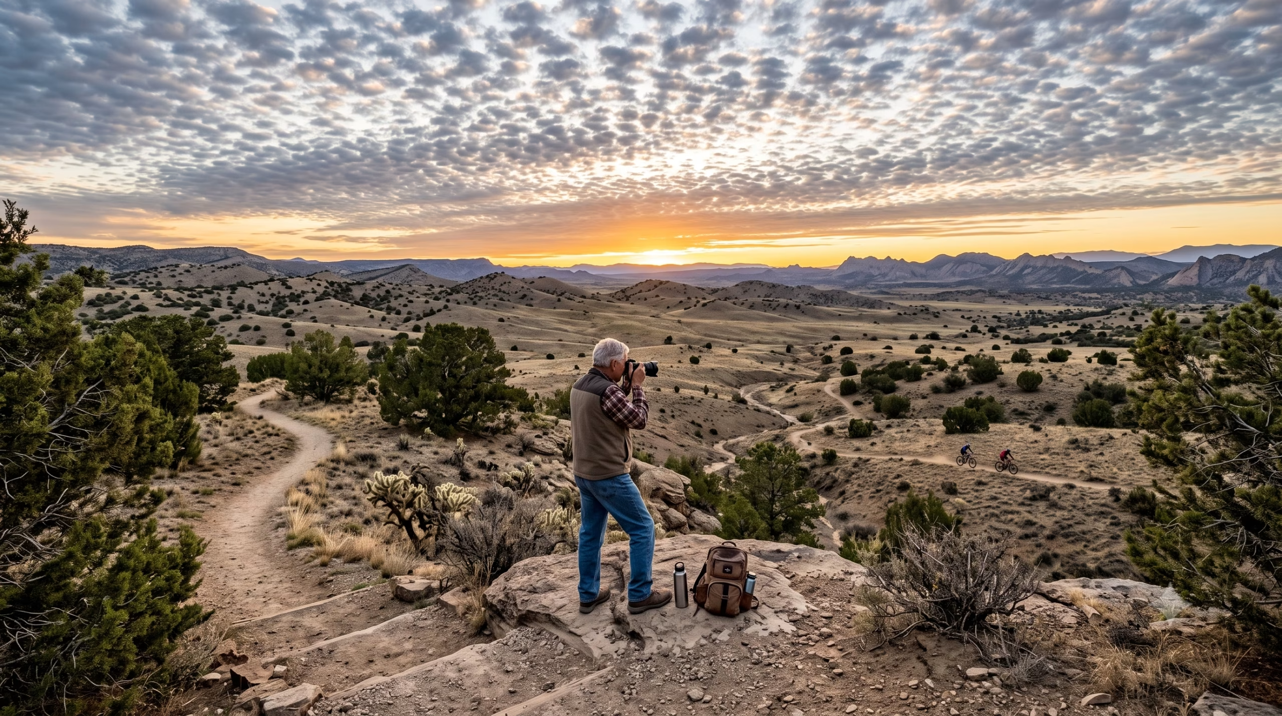
I pulled the Subaru into the gravel lot at the Cowboy Shack Trailhead just as the first amber rays were washing over the high desert. The air was a crisp, glorious low 60s, smelling faintly of sun-baked earth, pinon, and dew-damp sagebrush. Overhead, the sky was decorated with soft, white puffy clouds—the kind that make a photographer's heart skip a beat.
I checked my camera strap, took a deep breath of that thin, mile-high air, and set out.
My Sunrise Trail Loop:
[ Cowboy Shack Trailhead ]
        │
        ▼
  (Shepherd’s Trail) ──► [ Heaven’s Gate Overlook ]
                               │
                               ▼ (Sophie’s Spur)
                        [ Blue Moon Trail ]
                               │
                               ▼
                        [ Moo’s Milestone ]
                               │
                               ▼
  (Shepherd’s Trail) ──► [ Return to Subaru ]
Starting on Shepherd’s Trail, the singletrack path winds smoothly through high-desert savannah, surrounded by rolling hills dotted with cholla cactus and dark green juniper. I stepped lively up toward Heaven’s Gate Overlook. The climb gives just enough gentle resistance to let an old cowboy know his knees are still working, rewarding you at the top with a breathtaking, 360-degree vista of the Galisteo Basin.
Standing up there at Heaven's Gate, watching the clouds cast massive, drifting shadows across red-and-gold sandstone ridges, I set up my camera and shot a few photos. The sheer vastness of the landscape is staggering. I couldn't help but think: The next best way to start a day like this is casting nymphs at native rainbows on the Cimarron River! But standing on a desert ridge with wind in your hair isn't a bad second place.
From the overlook, I looped back via Sophie’s Spur—which always brings a smile to my face, thinking of my youngest granddaughter back home—and connected onto Blue Moon Trail. The trail led me past Moo’s Milestone, a nod to the area's deep cattle-ranching heritage, before merging back onto Shepherd’s Trail to bring me right back to the trusty Subaru, right on time to head home to Paulette for breakfast.
What Makes the Galisteo Basin Preserve So Special?
For anyone passionate about Hiking the Galisteo Basin Preserve, this 10,000-acre sanctuary is nothing short of a high-desert paradise. Managed with deep stewardship to balance conservation and community access, the preserve features over 48 miles of publicly accessible, multi-use trails designed for hikers, mountain bikers, and equestrians alike.
| Preserve Quick Facts | Details |
|---|---|
| Total Area | ~10,000 Protected Acres |
| Trail Network | 48+ miles of non-motorized, singletrack & dirt paths |
| Allowed Uses | Hiking, Trail Running, Mountain Biking, Horseback Riding |
| Elevation Range | ~6,200 ft to 6,600+ ft |
| Dog Policy | Allowed on leash (pack out all waste!) |
Unlike paved city parks, the preserve maintains a wild, authentic character. The trails are well-marked with junction signs, making navigation straightforward whether you want a quick 45-minute morning loop like mine or an all-day trek across open country.
A Deep Walk Through History and Cultural Heritage
When you step foot on these trails, you aren't just walking on dirt—you're walking through thousands of years of Southwestern human history. long before it became a preserve or cattle range, this basin was a bustling crossroads.
- The Ancestral Puebloans: Between 1100 and 1300 CE, thousands of Indigenous people settled in the basin, building massive "super-pueblos" such as San Cristóbal, San Lázaro, and Galisteo. They farmed corn, beans, and squash along the arroyos, leaving behind thousands of petroglyphs etched into the dark basalt cliffs.
- Spanish and Ranching Era: Spanish explorers and colonists arrived in the 1600s, followed later by generations of Mexican and American ranchers. The very trailhead I started at—the Cowboy Shack—gets its name from the historic livestock operations that once defined life out here.
Having spent my boyhood on a cattle ranch in Kansas, seeing old wire fences, weathered windmills, and historic trail names like Moo's Milestone gives me a deep sense of connection to the generations of working men and women who tended this soil.
Protecting a Fragile Landscape
While the vastness of the basin makes it look rugged and indestructible, the high desert ecosystem is surprisingly delicate.
Trail Steward Note: Always stay on the designated singletrack! The dark, crusty soil visible along the trail edges is often biological soil crust (cryptobiotic soil)—a living community of cyanobacteria, lichens, and mosses that takes decades to grow. It prevents wind erosion and holds vital moisture for desert plants like Apache plume, blue grama grass, and four-wing saltbush. One stray boot print can destroy decades of nature's hard work.
Always practice Leave No Trace: pack out every bit of trash, keep dogs leashed to protect nesting wildlife like roadrunners and jackrabbits, and give any grazing stock or horses plenty of wide, quiet berth.
Weather and Hiking Seasons in the Basin
One of the greatest features of Hiking the Galisteo Basin Preserve is that it offers true year-round recreation, though every season brings its own flavor:
1. Spring (March – May)
Crisp and bright, spring brings blooming yellow snakeweed and hedgehog cacti. Be prepared for strong afternoon winds and sudden shifts in temperature.
2. Summer (June – August)
Early mornings are absolute perfection, just like today! Temperatures usually start in the low 60s at dawn. However, summer heat can soar into the 90s by midday, and afternoon monsoon storms bring sudden lightning and torrential rains that can quickly turn dry arroyos into rushing torrents. Rule of thumb: Hike early and be off exposed ridges by 1:00 PM.
3. Autumn (September – November)
Ask any local: fall is the golden hour of New Mexico. Mild 70-degree days, clear blue skies, and cottonwoods along the arroyos turning brilliant shades of molten gold make autumn hiking unbeatable.
4. Winter (December – February)
While high mountain trails are buried under deep snow, the basin remains largely dry and accessible. Crisp 40-degree daytime highs under a bright sun make for ideal winter walking, though trails can become muddy right after a snowfall melts.
Getting There from Santa Fe
Getting out to the preserve from Santa Fe couldn't be simpler, making it the perfect morning escape before the city wakes up.
- Head South: From Santa Fe, take US-285 South toward Lamy/Clines Corners.
- Drive ~12 Miles: Proceed south past the turnoffs for Eldorado at Santa Fe.
- Turn into the Preserve: Look for the marked entrance signs for the Galisteo Basin Preserve on your right (west side of US-285).
- Reach the Trailhead: Follow the smooth gravel access road, bearing right at the fork, to arrive directly at the Cowboy Shack Trailhead parking area.
The Horizon Awaits
By the time I loaded back into the Subaru, my camera card was full of fresh morning light, my legs felt energized, and my mind was quieted by the sheer expanse of the Southwestern sky.
Whether you're an old outdoor enthusiast like me who spent his life watching light shift across mountain peaks, or someone stepping out into the high desert for the very first time, Hiking the Galisteo Basin Preserve offers a peace that stays with you long after the dust settles on your boots.
Now, if you'll excuse me, Paulette has the coffee brewing back at Casa Santa Fe—and there’s no better way to top off a sunrise trail hike than a hot breakfast with the love of your life.
Until next time, keep your camera ready, leave the trail better than you found it, and I’ll see you out on the path!
0 Comments